For the chatroom-challenged, BTDT is "been there, done that" --- that's my feeling on Quartzsite right now. I had some good times, saw some neat stuff, but don't really feel tip-top about the Q experience. In all fairness, I suppose it's my own fault for not checking temperatures a little more closely, but watching the weather channel off and on for years left me with the impression that Southwest Arizona -- all of it -- is warm in the winter. That's why all these snowbirds gather in Q and the surrounding area, right? ... wrong! They go there for socializing, flea-marketing, ATVing, and the January activities. The thermometer on the shady side of my RV never topped 60 in the daytime and consistently hit 30 degrees at about 2 AM. Now that may be warm weather to Yankees and Canadians, but it's too darn cold for this Alabama/Florida/Texas boy.
Now I suppose if I'd been more prepared -- like with a heater that didn't run my battery down in 3 or so hours -- that 2 AM freeze wouldn't have bothered me so much. That's why I was always up at 2 AM -- when the temp hits 30, I start worrying about my pipes freezing. I've always feared this problem, assuming it would require some major teardown to get frozen pipes fixed in an RV. So I'm up at 2, crank up my truck, plug in the pigtail to provide enough electricity, and run the heater for an hour or so. Not my idea of a good time!
However, don't think I'm not glad I went. Just didn't stay as long as anticipated. Learned some interesting stuff and saw some really unique sights. Even though things didn't turn out exactly as expected, I surely wouldn't have wanted to miss Quartzsite and all it has to offer.
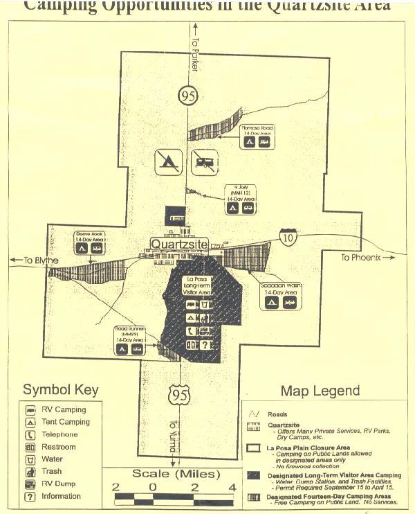
First thing I learned was the it's Quartzsite, not Quartzite (i.e., Site, not Zite). That's probably why I didn't get any decent hits when I tried to research Quartzite on the internet before going out. Turns out it was originally zite, but somebody misspelled it awhile back and the new spelling stuck. Second thing I learned was that the desert around Q is not sandy and soft, but hard and rocky. It's all pretty level, also, so you see RVs parked almost everywhere around the town. Coming in on Business Loop 10 (parallel to I-10) from the East, I began seeing RVs parked here and there in the desert just off the highway a few miles out of town. Turns out that the intersection of Business 10 and State Highway 95 is a four-way stop that's about the busiest intersection in town. If you go any direction from that intersection, you first see RV parks, then eventually get to the 14-day free parking (boondocking) areas. There are also 7 Long-Term Visitor Areas (LTVAs) West and South of Q, where you can dry-camp for $20 per week or $100 from September 15 through April 15. Paying the money allows you to use whatever amenities are available for the particular LTVA. All havetrash disposal, some have phones, dump stations, water, and restrooms. There's a good map showing LTVAs in Arizona/California on the internet, and I've included an additional one I picked up showing Quartzite LTVAs and Free Areas.


My Travel Log
Nothing in this site is copyrighted -- I'd be honored if you'd
reuse anything you find here for your website

3. Quartzsite, BTDT
The most fantastic thing I saw using the map was Palm Canyon (#15). The map got me close and the road signs led me in. After driving over 7 miles on a dusty, rocky road, I came to the parking area. About a 20-minute hike gets you to the middle of the canyon, where about 40 cute little palm trees are growing on the side of the mountain. They have very clear signs, pointing to precisely where one looks to see the palms. If you're familiar with Florida palmettos, that's about the size of them. They look almost like giant air-plants stuck on the rock cliff. The first half of the walk was rather steep and sunny, so very warm. The last half was flatter and shady, so very cold. Best to wear a short-sleeved shirt and carry a long-sleeved one. If you want a picture, get there before 2:00 PM so the palms are in the sun. And bring a good camera -- my little Polaroid couldn't handle the fact that I was standing in the shade and the palms were in the sun. Never could get a decent picture, but I'd say Palm Canyon was one of the high points of my day trips. Below are some indecent Palm Canyon pictures.
Quartzsite - Camping Areas
The map on the right shows the La Posa LTVA and the five 14-day free areas. Got the map from the host at La Posa. On December visit, I stayed at Road-Runner on South 95 at Mile-Marker 99. Click here for CA/AZ LTVA map online. Click the map to enlarge it.
Speaking of maps, one that I found very useful was the Chamber of Commerce map of "44 Historical Sites & Day Trips" -- get it for $1 donation at the C of C office on Main Event Lane just North of I-10 exit 17. It's not always the easiest thing to follow, but I wouldn't have found any of these sites without their map. I marked 8 of the 44 that I wanted to see, then started out. According to the map, travelling up the frontage road takes you to the 47-Armed Saguaro (#9), Old Mine Sites (#39), Intaglios (#37), and Q Mountain Trail (#38). Without going into alot of detail, let me just say I'll challenge you to find any of these without help. When I passed a sign saying "Private Road - Travel at Your Own Risk" on the frontage road, I decided #9 was out of the question. I looked where #39 was supposed to be and just saw some mobile homes. I found #37 by asking some hikers -- didn't know what an Intaglio was, so didn't really know what to look for. They said to look for a fenced-in area, which I did. Found some patterns cleared in the dirt -- guess they pointed at some other intaglios, but never did see them. Some other tourists pointed me at Q Mountain -- imagine my surprise when I came around to the town side and found a huge Q painted there -- about 30 feet high. Guess I was the only one in town who hadn't seen it as soon as they arrived in Quartzsite ... lol. Below are some Q Mountain and Palm Canyon pictures.
I took these with a cheap Polaroid, I'm a lousy photographer, the scanner loses some of the resolution, ... etc., etc. are my excuses for the pictures not being of very high quality. Sorry about that.
Where appropriate, I provide an edited version to emphasize some aspect of the snapshot.
Quartzsite - First Sunset
If the background wasn't so bright, you'd be able to see mountains in the distance. Not important -- just wanted to get a shot of the 5th wheel sitting among the Saguaro cacti. Also managed to get myself in the shot ... lol
Quartzsite - First Sunrise
Bright background again, but you can see mountains between the cacti on the left. Got myself in the shot again.
Quartzsite - First Sunrise (edited)
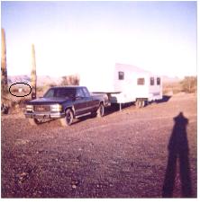
Was attempting to show nearest neighbor. Notice circled RV on the left. Probably a couple of hundred yards away. This was in December -- probably more crowded when I return in January.
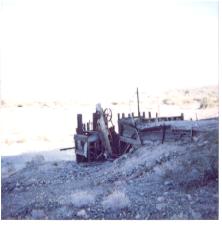
LEFT: Q Mountain: Bright background again -- hiked up the mountain and ran into some kind of abandoned mining gear.
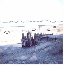
RIGHT: Q Mountain (edited): Besides showing the mining gear, I had also intended to show RVs in the valley below. Since neither the RVs or the mountains showed, I drew them in here.
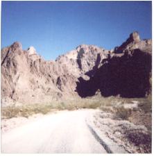
Palm Canyon Entrance: View approaching parking area. The canyon is at the left end of the shadow.
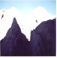
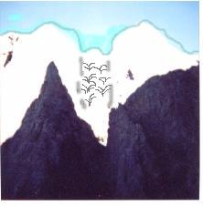
Palms in Palm Canyon: The sun is at my back and what you're seeing here is the shadow of the mountains behind me. The mountains in view are in bright sunlight.
Palms (edited): I darkened the sky some and drew the outline of the mountains. The palms are in the crevice in the center of the shot, about 50 yards away.
After Palm Canyon, I went looking for Crystal Hill (#6). After driving 6 miles on a very rocky road, I got to a place where the sign said "Boundary - Crystal Hill". Great, but I didn't see anything spectacular and there were no further signs. After that disappointment, I decided I'd seen (or tried to see) enough of the sites.
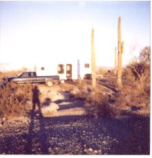
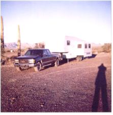
While in Q, I stayed at the 14-day free parking Road-Runner area South on Highway 95. I had about 5 acres to myself, parking among the cactus, and it was about as peaceful and picturesque as any place I've ever camped. There are mountains on all four sides, providing some beautiful sunrises and sunsets. Only talked to one neighbor -- 2 RVs pulled into "my yard" the second day (about 100 yards away) and stayed one night. One of the vehicles was a really strange-looking white vehicle -- looked sort of like a HumVee stretched about 3 times higher and twice as long. I went over and asked what it was. Turns out they were from British Columbia and it was a Mercedes-Benz Motor Coach. Thought I'd seen them all, but this one was really different. Only other people I talked to were the parking area "hosts", since all my other "neighbors" were too far away. Arrived at Road-Runner Wednesday, December 15th and stuck it out for 3 nights. Cooked out a couple of times, sat out under the stars for a time each night, and really felt like a pioneer. Late Friday I decided I needed to go to a campground and get the battery charged up again and I really hoped I'd find warmer nights to the South. Left Saturday morning to move to Yuma for a time. More coming ... Below are some Road-Runner sunrise/sunset pictures.
PostScript: I'm thinking about going back up to Q in January if I can figure out something to do about the heat problem. It really looks like that's when all the action happens and it would be a shame to travel this far and not see the "main event". Another PostScript: Saw the biggest road-kill of my life today -- a camel on the side of Highway 95 South of Q. Bet that really surprised some poor tourist! Camels were brought to Arizona in the 1800's as an experiment, but most were eventually set loose in the desert. Some still roam wild in the area.